Showing 61 items matching closer settlement
-
 Tatura Irrigation & Wartime Camps Museum
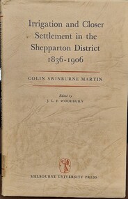
Book - Irrigation and Closer Settlement in the Shepparton District 1836 - 1906, Colin Swinburne Martin
... Irrigation and Closer Settlement in the Shepparton District...Irrigation and Closer Settlement in the Shepparton District...irrigation and closer settlement around Shepparton...Irrigation and Closer Settlement in the Shepparton District ...Green hardvocer with very dark cream wrap around cover, with black and read writing , front fly leaf has description of contents. Stamped inside is Churchlands Teachers college library, Pearson St, Churchlands, Western Australia 6018. Same stamp is also on back page of book. There are brown marks inside the cover that indicate it was taped down at some stage in it's lifenon-fictionirrigation and closer settlement around shepparton district, mcallister, colin swinburne martin -
 Tatura Irrigation & Wartime Camps Museum
Book, Closer Settlement Days
... Closer Settlement Days...closer settlement days... Tatura the-murray Book Closer Settlement Days White plastic front ...Story of three Scottish imigrant families - Geals, Stark, Forbes. Arrived in Australia 1924White plastic front cover. Black spine and backcover. Black letters title CS Days in the Goulburn Valley by Agnes Mary Brown (Nessie)closer settlement days, geals, stark, forbes, brown a, brown n, undera, tatura, closer settlement gv, books, history, local -
Tatura Irrigation & Wartime Camps Museum
Book - Family History, Agnes Mary Brown (Nessie), Closer Settlement Days
... Closer Settlement Days...Title Closer Settlement Days in the Goulburn Valley... Tatura the-murray Book - Family History Closer Settlement Days ...Story of three Scottish immigrant families - Geals, Stark and Forbes. Arrived in Australian 1924.White plastic front cover, black spine and back cover. Black letters. Title Closer Settlement Days in the Goulburn Valley by Agnes Mary Brown (Nessie).geals family, stark family, forbes family, agnes mary brown (nessie), scottish migrants -
 Bendigo Historical Society Inc.
Document - Mining in Bendigo, 1909 to 1939
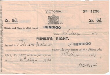
... victorian lands department and closer settlement commission... and Closer settlement Commission 8663.3f Receipt from the Lands... victorian lands department and closer settlement commission albert e ...Documents related to Mining in Bendigo, purchase of a property. 8663.3a Front of Miners Right issued to Robinson Fairbairn 8663.3b Back of Miners Right issued to Robinson Fairbairn 8663.3c Valuation from Shire of Marong, 14 Bray St., California Gully 8663.3d Receipt from the Lands Department and Closer settlement Commission 8663.3e Receipt from the Lands Department and Closer settlement Commission 8663.3f Receipt from the Lands Department and Closer settlement Commission 8663.3g Receipt from the Lands Department 8663.3h Receipt from Albert E. Brown Land and Stock Agenthistory, mining, robinson fairbairn collection, miners right, victorian lands department and closer settlement commission, albert e brown land and stock agent -
Whitehorse Historical Society Inc.
Letter - Correspondence, Obtaining a grant of Crown Land at rear of Myrtle Grove, 1932
... Victoria. Closer Settlement Board...Correspondence between Council and Closer Settlement Board... and Closer Settlement Board re land in Pakenham Street including ...Correspondence between Council and Closer Settlement Board re land in Pakenham Street including plans of allotments.Correspondence between Council and Closer Settlement Board re land in Pakenham Street including plans of allotments. Also further correspondence re land being sold by Malcolm Sheehan to Dal Hear.Correspondence between Council and Closer Settlement Board re land in Pakenham Street including plans of allotments.pakenham street, blackburn, myrtle grove, blackburn, shire of blackburn and mitcham, sheehan, malcolm, hearn, dal, victoria. closer settlement board -
 Ballarat Diocesan Historical Commission
Poster, Government Land Sales Poster
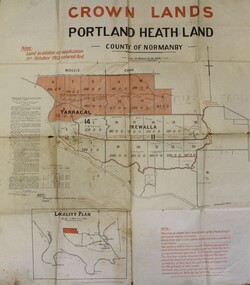
... Closer Settlement, Soldiers Settlement, Government Poster... of closer settlement was first authorised under the provisions... poster advertising land sales to promote closer settlement ...Government poster advertising land sales to promote closer settlement in Portland area. The acquisition of land for the purpose of closer settlement was first authorised under the provisions of the Land Act 1898. In 1917 under the provisions of the Discharged Soldiers' Settlement Act, the scheme reverted to the Soldiers' Settlement scheme when the government undertook the settlement of discharged soldiers on lands set aside exclusively for them as a reward for their war service.closer settlement, soldiers settlement, government poster. land sales, portland. -
 Myrtleford and District Historical Society
Tobacco bale stencil
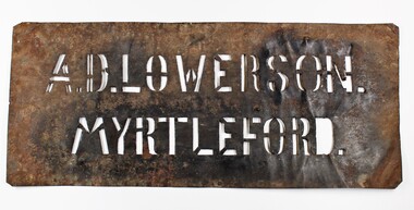
... closer settlement board... of 19 blocks assigned by the Closer Settlement Board on the 700... acquired one of 19 blocks assigned by the Closer Settlement Board ...Stencil used by Sgt. Albert David Lowerson, VC, a soldier settler on Merriang Estate near Myrtleford. Lowerson acquired one of 19 blocks assigned by the Closer Settlement Board on the 700 acre estate in 1920. The stencil marked bales of cured tobacco leaves prior to shipment to Melbourne. Lowerson was one of the few successful soldier settler farmers in the district, operating a piggery, dairy farming and growing tobacco for almost 20 years on "St. Quentin". (Lowerson was awarded the Victoria Cross at Mont St. Quentin on September 1, 1918.) His success and status enabled him to lead a submission on farm debt and infrastructure problems when the soldier settlement scheme was being reviewed at government level. He was active locally on these issues and supported fund raising for a war memorial, memorial hall and veteran welfare.The stencil represents the achievements of A.D.Lowerson, VC as an isolated example of success as a WW1 soldier settler and as a local identity who stridently supported the need for recognition and support of ex-service personnel.Stencil made of thin sheet metal, rusted .Wording of stencil "A.D.LOWERSON. MYRTLEFORD." lowerson a.d., merriang estate, myrtleford, closer settlement board, tobacco, st. quentin, victoria cross, world war 1 -
Federation University Historical Collection
Book, Frank Hurley, An Event That Never Happened: The history and politics of decentralisation in Victorian and New South Wales 1885-1985 (Thesis), 1989
... Closer settlement acts... doctorate decentralisation ppoulation economics policy Closer ...This thesis is an account of movements and policies for decentralisation of population and economic activity away from metropolitan to non-metropolitan areas in Victoria and New South Wales between 1885 and 1985. Red hard covered thesis undertaken for a Doctory of Philosphy ot the University of Melbourne. frank hurley, thesis, doctorate, decentralisation, ppoulation, economics, policy, closer settlement acts, urbanisation, decentralisation league, war and reconstruction, central planning, town planning, victorian decentralisatoin league, owen paper mill, slough estate, noel mobbs, ballarat common, edgar bartrop, australian paper mills, bendix mintex, ball, ballarat development committee -
Marysville & District Historical Society
Article (item) - Magazine Article, Coranderrk-A Station Never a Mission, Unknown
... closer settlement act... native police corps merri creek closer settlement act badger ...A magazine article on the history of Coranderrk based on a historical component of a survey of Coranderrk Station.A magazine article on the history of Coranderrk based on a historical component of a survey of Coranderrk Station.coranderrk, coranderrk station, dr marie hansen fels, healesville and district aboriginal community, john green, healesville, acheron river, mohican, native police corps, merri creek, closer settlement act, badger creek, hops, cattle, royal commission of 1877, board of enquiry 1881, lake tyers -
Ballarat Heritage Services
Document, Helen Doyle & Context Pty Ltd, Moyne Heritage Study Stage 2 Vol 2, 2006
... closer settlement... Yangery Land selection act closer settlement soldier settlement ...141 page heritage studymoyne, minhamite, port fairy, mt shadwell, mt rouse, mt napier, mt eccles, tower hill, dhauwurdwurrung, djabwurrung, giraiwurrung, caramut, james atkinson, special survey, william rutledge, yangery, land selection act, closer settlement, soldier settlement, framlingham, lime burning, atkinson’s belfast survey, belfast, killarney, crossley, aboriginal protectorate, lake condah, hexham, hexham common school, koroit convent, hurling, mile posts, kirkstall, ballyhurst, dundonnell, curdievale, ballangeich, hawkesdale, irish, scottish, aborigines, tower hill cemetery, st brigid’s catholic church -
![Parish of Nunawading, County of Bourke showing land acquired under Closer Settlement Acts [C 1887]](https://victoriancollections.net.au/media/collectors/56f368632162f118acbff12e/items/60d923316e5f99545134f182/item-media/6147b12a4806c7ae686c24e4/item-fit-380x285.jpg) Whitehorse Historical Society Inc.
Whitehorse Historical Society Inc.Map, Parish of Nunawading, ca 1887
... acquired under Closer Settlement Acts [C 1887] 1947 reprint.... showing land acquired under Closer Settlement Acts [C 1887] ...Parish of Nunawading, County of Bourke showing land acquired under Closer Settlement Acts [C 1887]Parish of Nunawading, County of Bourke showing land acquired under Closer Settlement Acts [C 1887] 1947 reprint.Parish of Nunawading, County of Bourke showing land acquired under Closer Settlement Acts [C 1887] parish of nunawading, box hill, maps, land settlement -
Tatura Irrigation & Wartime Camps Museum
Book, Girgarre Living History, Girgarre. Girgarre Living History, 2016
... Girgarre - an extraordinary history, closer settlement... - an extraordinary history, closer settlement, soldier settlement and family ...Girgarre - an extraordinary history, closer settlement, soldier settlement and family stories.Tells of the history of Girgarre, with information obtained from a collection of stories and extensive research into the Closer and Soldier Settlement of the districtRectangular shaped book ,aerial photo of the township and environs of Girgarre, on Market Day, September 2013. Photo extends over front & back covers, highly colourful cover. 251 pages. B/W photos and maps of local families and local scenes.girgarre, family histories, soldier settlement -
Tatura Irrigation & Wartime Camps Museum
Book, Girgarre Living History, Girgarre. Girgarre Living History, 2016
... Girgarre - an extraordinary history, closer settlement... - an extraordinary history, closer settlement, soldier settlement and family ...Girgarre - an extraordinary history, closer settlement, soldier settlement and family stories.Tells of the history of Girgarre, with information obtained from a collection of stories and extensive research into the Closer and Soldier Settlement of the districtRectangular shaped book ,aerial photo of the township and environs of Girgarre,on Market Day, September 2013. Photo extends over front & back covers, highly colourful cover. 251 pages ,B/W photos and maps of local families and local scenes.girgarre, family histories -
Tatura Irrigation & Wartime Camps Museum
Fence Droppers, late 19th century to early 20th
... wire fences especially with closer settlement areas like Tatura... with the earliest wire fences especially with closer settlement areas like ...Split timber fence droppers were used with the earliest wire fences especially with closer settlement areas like Tatura. The donors family were Tatura hardware and timber merchants so may have made and supplied these to farmers. 3 wooden dropper split with axe to shape rather than sawn. 6 holes for wire to pass through (6 gauge). Used between posts to support wires. Made from straight grained timber, grey box.fence dropper, wood fence dropper, fencing material -
Federation University Historical Collection
Booklet, The Stock Exchange of Melbourne: Monthly Official List of Quotations and Prices Current, 1909
... brokerage, Closer Settlement Loans. Banks. Building Societies... booklet. Contents include brokerage, Closer Settlement Loans ...Small, brown, soft covered booklet. Contents include brokerage, Closer Settlement Loans. Banks. Building Societies, Banking and Financial Institutions, Gas, Insurance, Breweries, Trustee, mines, Goldmines in Ballarat, Daylesford, Stawell and District, Dredging Companies, Coal mines, Municipal Loans, Metal Rates since 1888, Calls Due 13 January 1909, List of Legal Managers and Secretariat of Mining Companies, Member of the Melbourne Stock Exchange.non-fictionmelbourne stock exchange, stockbrokers, f.w. holst, w.s. ham, walter s. ham, f.w. were, r.e. tweddell, w.d. thompson, w.m. williams, n.m. dudgeon, w.m. acheson, e.g. ross, j.h. dill, s. stretch, j.c. bell -
Warrnambool and District Historical Society Inc.
Publication, Collett and Bain, Heytesbury Forest School, c.1971
... . The Heytesbury Forest was largely deforested by the Bailey Closer... deforested by the Bailey Closer Settlement Scheme of the 1930s ...This booklet, by Rosamund Duruz, gives the history of the schools in the Heytesbury Forest area. The Heytesbury Shire Council was established in 1863 and the first schools in the area opened in the 1870s. Most of them were closed when Timboon Consolidated School (later Timboon High School) opened in 1948. The Heytesbury Forest was largely deforested by the Bailey Closer Settlement Scheme of the 1930s and later the establishment of more farming properties in the 1950s. This booklet is of interest as a comprehensive history of the schools in the Heytesbury Forest area pre 1970. It will be useful for researchers. This is a soft-cover booklet of 63 pages. The cover is a cream colour with brown images of trees and a school on the front cover. The booklet includes a map, a sketch and several black and white photographs. The booklet is bound with metal staples.schools in heytesbury forest, victoria, rosamund duruz, historian, history of warrnambool -
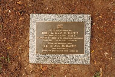 Phillip Island and District Historical Society Inc.
Photograph Album, Kodak, Phillip Island Cemetery, c 1990
... as a sheep and cattle run for 45 years until Closer Settlement... as a sheep and cattle run for 45 years until Closer Settlement ...The Album was compiled by Nancy McHaffie late 1990's, with the assistance of Edith Jeffery's, with her book "Garden of Memories" and extensive knowledge of Phillip Island. The Cemetery lies back from the road and is surrounded by Manna Gums, rare Peppermint Gums, Blackwoods and other native trees. In all 25 acres of land were set aside as Crown Land in the land settlement of 1868. There are 6.2 acres of wetlands near the cemetery entrance.4 photographs relating to the McHaffie family. 466-15 & 466-16: Noel Wemyss & Vernon Suter Wemyss McHaffie were grandchildren of the first permanent European Settlers of Phillip Island (John David & Georgianna McHarrie who leased the whole Island as a sheep and cattle run for 45 years until Closer Settlement in 1868 reduced their holding to 640 acres and who are buried at the St. Kilda Cemetery, Melbourne). Noel's ashes are interred at the Phillip Island Cemetery and Vernon's were scattered at Ventnor Philip Island at the site of the original homestead. 466-17 & 466-18: As per the Plaque: "Mulberry Tree: Muberry cutting from original tree planted by John D McHaffie First Settlers Phillip Island 1842. Plaque by courtesy Cherry McFee 1987.phillip island cemetery, nancy mchaffie, edith jeffrey -
Warrnambool and District Historical Society Inc.
Document, Wollaston sale, 1919
... stands today. In 1919 the Closer Settlement Board of Victoria... stands today. In 1919 the Closer Settlement Board of Victoria ...This is a poster advertising the sale of part of the Wollaston Estate in Warrnambool in 1919. The sections for sale were Allotments 1, 18 and 19 which included the Wollaston Homestead. The original Wollaston property of 679 acres was selected by Thomas Manifold in the late 1840s. This land, on the northern side of the Merri River, near the Woodford Road was three kilometres from the Warrnambool town. The first farmer we know who leased the property was William Simpson. Walter Manifold inherited the property and he took it over in 1884. The swing bridge he built in 1890 still stands today. In 1919 the Closer Settlement Board of Victoria acquired Wollaston and 17 lots were sold to returned soldiers for farming purposes. By 1930 there were only five soldier settlers remaining. In 2009 further subdivision took place with lots sold for residential purposes. The homestead allotments were sold separately in 1919 with various owners of the homestead itself recorded since that time. This poster is of interest as it shows the areas of the Wollaston Estate which were sold in 1919. The history of this estate is well-documented and of importance in the history of Warrnambool. This is a sheet of paper with red and black printing and a map of the Wollaston Estate which is photo-lithographed. The sheet has been folded three times. It has some small tears at the top of the page. wollaston, history of warrnambool, walter manifold -
Warrnambool and District Historical Society Inc.
Correspondence (Rose Park), 1940s
... land was sold for closer settlement. Stan Baulch... was sold for closer settlement. Stan Baulch was a prominent member ...These are four letters and a document regarding the proposal in the 1940s by the Victorian Department of Lands and Survey to acquire sections of the property, Rose Park, to establish several Soldier Settlement farms. Rose Park, near Willatook, was owned by Stan Baulch (1897-1980), the son of Samuel and Eliza Baulch. Samuel Baulch had acquired the property of Dunmore, between Macarthur and Hawkesdale, in 1893 and Stan had inherited portion of this property after his father’s death. He named his portion Rose Park. The Soldier Settlement Commission wanted to acquire 1500 acres of Rose Park but Stan Baulch argued successfully that the management of his farm could not withstand the loss of so much land and eventually 300 acres of Rose Park land was sold for closer settlement. Stan Baulch was a prominent member of the Warrnambool and District Historical Society for many years and contributed many articles and booklets on local historical matters. This correspondence is of interest as an example of the establishment of Soldier Settlement farms in Victoria post World War Two and the difficulties faced by some property owners opposed to the acquisition of their land. These items will be useful for research. .1 A six-page letter written in pencil .2 A two page letter in black typing ( contents as in .1 above) .3 A one page letter, typed, with a handwritten signature .4 A sheet of paper containing a statement re purchase of land with some inserted handwritten material .5 A two page letter with handwritten material baulch family, western district, victoria, history of warrnambool -
 Warrnambool and District Historical Society Inc.
Original Document, Map: Agricultural area of Ballangeich 1865, 1865
... now more open to closer settlement and a greater variety... and sheep based were now more open to closer settlement ...George Eddington arrived in Australia in 1839 and named and established property in 1841 calling the property Ballangeich after a Pass near his home town of Stirling in Scotland. It is situated 151 miles west of Melbourne and to the south of Mortlake and was originally part of the Mortlake shire, which was proclaimed 26th Jan 1864. Nearest streams are the Hopkins Riverand Lyall and Drysdale creek running through good agricultural land. This map relates to the breaking up of large runs which the Victorian government enabled through selection acts of the 1860's. The previously larger runs which were mainly cattle and sheep based were now more open to closer settlement and a greater variety in farming.The lots range in size from approximately 50 acres to around 600 acres.Some areas are set aside for reserves. By 1886 the population of Ballangeich had grown to around 600 with an hotel, three state schools and a church.Tri weekly coaches ran to Colac, Warrnambool and Camperdown providing access to supplies mail and communication. This map is typical of many which were produced in the 1860's in Victoria during a significant period of Victoria's and Warrnambool district history.Rectangular light card paper with black text showing allotments of land The area is coloured in green with scale at bottom right cornerAt the top: Plan of the Agricultural area of Ballangeich 1865 At the bottom left: Prepared by the Board of Lands & Works in accordance with the Amending Land Act 1865 Lands & Survey Office Melbourne 13th April 1865. With signaturehistory of warrnambool, ballangeich, land surveys victoria 1865, lands act 1865 victoria, ballangeich map 1865 -
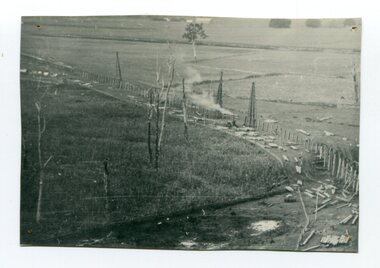 Orbost & District Historical Society
black and white photograph, 1916
... 'Developmental Railways', designed to open remote areas to closer...', designed to open remote areas to closer settlement, even ...This photograph shows the pile drivers at work in the construction of the viaduct across the Snowy River flats. The Snowy River Floodplain Railway Bridges, two sequential and exceptionally long and low timber railway bridges on the Snowy River floodplain just west of Orbost, were built in 1916, and provided the original terminus point for the Bairnsdale-Orbost railway. The bridges are 770 metres and 183 metres long respectively. The shorter bridge is of uniformly 4.57 metre timber-beam construction, and has a sweeping curve in its deck. The longer bridge has a combination of 4.57 metre and 6.1 metrespans, and two 3.66 metre spans. The bridges are constructed from 'Southern Mahogany', Eucalyptus Botryoides, which grew along the coast east of Bairnsdale. The Snowy floodplain bridges were initially built in the context of an early twentieth-century interest in American-style 'Developmental Railways', designed to open remote areas to closer settlement, even if that meant running at a loss. The line was closed in August 1987. (information from Victorian Heritage Database)This item is associated with the history of the Orbost-Bairnsdale railway line and therefore reflects the role that the rail line played in the social and economic history of Orbost.A black / white photograph of the farming flats at Orbost during the construction of the East Gippsland railway.orbost-railway east-gippsland-railway viaduct-orbost transport railway -
 RSL Victoria - Anzac House Reference Library and Memorabilia Collection
Photograph, Macleod Repatriation Sanitorium, circa 1914
... the Closer Settlement Board in 1909 . The Mont Park Hospital... the Closer Settlement Board in 1909 . The Mont Park Hospital ...The former Mont Park/Bundoora Psychiatric and Repatriation Hospitals Complex consisted of seven hospitals on a site of 185 hectares. The site comprising the Mont Park and Strathallen estates was consolidated by the Victorian government by purchase and transfer from the Closer Settlement Board in 1909 . The Mont Park Hospital commenced in 1910 with the building of the Farm Workers Block . In 1912 the landscape gardener Hugh Linaker was employed to layout the grounds of Mont Park and other State mental hospitals. The other hospitals were gradually split off from the Mont Park administration to form separate entities included among these was the Macleod Repatriation Hospital (1915), An agreement was made with the Defence Department in 1914 for the latter to erect the Mont Park central block (the "Chronic Wards") for use as a Military Hospital, and for it later to revert to the State as portion of Mont Park Hospital. The buildings now known as the Chronic Wards were completed in this way in 1916 and used as the Australian General Hospital no. 16 for the duration of the war. One wing of this building was set aside for mental patients during this period. Silver gelatin photographww1, macleod repatriation sanitorium, mont park -
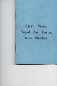 Lara RSL Sub Branch
Booklet, Sgts' Mess Royal Air Force Brize Norton, R.A.F. Station, Oxfordshire, U.K, circ 1939
... of the Royal Air Force. It is close to the settlements of Brize Norton.... It is close to the settlements of Brize Norton, Carterton and Witney. ...Sargent's, Mess Royal Air Force, Brize Norton Royal Air Force Brize Norton or RAF Brize Norton in Oxfordshire, about 65 mi (105 km) west north-west of London, is the largest station of the Royal Air Force. It is close to the settlements of Brize Norton, Carterton and Witney.Sgt's Mess Royal Air Force Brize Norton, R.A.F. Station, Oxfordshire, U.K. - Rules of Sergeant's Mess -
 Mortlake and District Historical Society
Letter
... kilometres distant. Francis Jones and descendants were closely... closely associated with the settlement of Grasmere (district ...This letter describes a business transaction of an item essential to conducting a mill in the days of the pioneers. The horse was purchased from Francis Jones at Grasmere some 45 kilometres distant. Francis Jones and descendants were closely associated with the settlement of Grasmere (district) and 'The Union', a well-known pastoral property still in existence today.The conduct of business in the 19th century could be slow and arduous. Horses were an essential component of business and communication. Their labour was pivotal to success and so their physical soundness (or otherwise) was vital. The horse trade was open to manipulation by the unscrupulous, selling unfit animals. Veterinary care and treatment was primitive, so a buyer could not be confident of a positive result, despite (as in this case) Jones' assurances of the triviality of the injury and Knights' capabilities. Handwritten letter on paper folden in half - water stained.Grasmere. April 4th 1864. Messrs. Hamilton & Co. I beg to acknowledge the receipt of yours of the 29th March enclosing a cheque for [pound sign] balance of the price of the bay mare for which I am much obliged to you for your punctuality in sending it. I enclose you a receipt for the the (sic) same. With reference to the swelling on the mares leg it could only have been there a very short time before you purchased her. It can easily be removed if the proper remedies are applied. M. Knights the veterinary surgeon will give you medicine that will remove it for a trifle. Hoping the mare will give you ample satisfaction. I am scy. (sic) [sincerely] yours respecfully Francis Jones. mortlake mill hamilton transport communication francis jones grasmere michael knights veterinary surgeon -
 Melton City Libraries
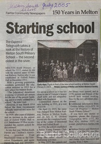
Newspaper, Melton Schools-150 years in Melton, 2005
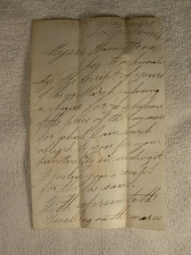
... coincided with the Exford ‘Closer Settlement’ estate... with the Exford ‘Closer Settlement’ estate at the beginning of the new ...Melton South "The establishment of a settlement of Melton South was induced by the opening of the railway in 1884. This subsequently prompted a number of industries, initially sawmills, and in the early twentieth century, chaff mills. This development coincided with the Exford ‘Closer Settlement’ estate at the beginning of the new century, boosting local population and produce, and the development of the chaff industry which employed many people in the Melton area. (Around 1912 the government had brought out English migrants to settle the Exford estate.) By c.1912 the small Melton Railway Station settlement had a boarding house (probably for chaff or sawmill employees), store, a small church and a hall. The Melton Valley Golf Club originated near the railway station in 1927 (in 1931 it moved to the present Melton links). In 1910 the community had built the large timber ‘Victoria Hall’, which became the focus of community life for several generations. In August of that same year AR Robertson MP and D McDonald applied for the establishment of a school on land set aside for that purpose by the Closer Settlement Board, near the Melton Railway Station settlement. District Inspector McRae recommended that a school for classes up to Grade 3 be established as an adjunct to the Melton State School. And so SS3717, ‘Melton Railway School’, was established in the leased Victoria Hall on 1st December 1911. Thomas Lang, head master at Melton since 1896, was in charge of both schools. As a ‘prep’ school only, it was necessary that the older Melton Railway Station settlement students travel to Melton SS430 at Unitt Street. Since 1912 local residents had been petitioning for the establishment of a separate school at Melton Railway Station on the grounds that it would be better if all children from the one home could attend the same school, and that the Victoria Hall was unsuitable as a school building. As a result an area of 2 acres - Allotment 8, Parish of Djerriwarrh, Exford Estate - was reserved for a State School on 4th March 1914. However the Department wrote that a school would not be established there in the near future, as ‘there is no likelihood in sight that the Railway Station settlement will increase in importance’. Parents persisted with their petitions to the Education Department, claiming that the Victoria Hall was too large, had no fireplace, that teachers were unable to use the wall for teaching aids, and that, being less than 20 metres away from a chaff mill employing 30 men, was too noisy. The turning point came when in 1920 the Hall Committee decided to increase its rent for the hall. In 1920 Head Teacher Lang advised the Education Department to discontinue SS3717 as an adjunct. The District Inspector supported this recommendation, and the schools separated in 1923. In April of that year 41 children, comprising Grades 1-8, moved into an almost completed brick building on the present site. On the 6th July 1923 the official opening of the school took place; after a ceremonial journey from the Hall to the school, speeches were given by the Hon AR Robertson and the Chief Inspector of Education. Everyone then journeyed back to Victoria Hall for a ‘bountiful repast’. (These dates are at odds with the date of 5th March 1925 given in Blake as the date the children occupied the new SS3717 brick school building. ) A teacher’s residence had been purchased for ₤500 in 1923, and the school’s name was changed to ‘Melton South’ in the same year. Even though the older Melton South pupils would no longer have to travel to the Unitt Street school, an additional brick room was still required at the Melton SS430 in that same year. In 1961 a new room was added to the school. In 1972, at the beginning of Melton’s boom as a satellite town, the number of enrolments was 224. The school has since shared in the exponential growth of the town of Melton, and at the time of its jubilee celebration (1983), 524 pupils were enrolled. Victoria Hall, neglected and vandalised, was demolished in 1992. It had been handed back to the Council on condition that it be replaced by a new hall, with the same name, and was commemorated by a plaque. Apart from the 1923 brick school building, and the railway station, none of the principal early Melton South public sites survive. Few early residential sites remain. (Further research will establish whether the house on the corner of Station Street and the railway line was the original teacher’s residence.)" Melton State School "On 17th May 1858 a State subsidised, combined Denominational School was opened by HT Stokes, with an attendance of about 30 children. This school was conducted in the wooden Melton Combined Protestant Church, situated on ‘a creek flat’ thought to be on the north side of Sherwin Street between Pyke and Byran Streets. It is likely that the Church had been established by 1855 and that the first minister was the Rev. Hampshire, who lived in Cambridge House on the Exford Estate. Ministers of the Protestant denominations were invited to hold services there. As there was only one resident Minister in the town (Presbyterian Mr J Lambie), laymen of the various denominations often spoke on Sundays. In 1863 this building was declared a Common School with the number 430. One of its first and most prominent headmasters was John Corr, who served from 1860 to 1864. Most of Mr Corr’s children also became teachers, including Joseph Corr, at the Rockbank school, and J Reford Corr and WS Corr, headmasters and teachers at numerous prestigious private secondary schools around Australia. John Corr purchased land alongside the school and elsewhere in and near Melton, became secretary and treasurer of the new Cemetery Trust, and by July 1861 was deputy registrar of births, deaths and marriages. He walked three miles every Sunday to teach at the Weslyan Sunday School he had established. Despite good reports from the Education Department Inspector, and burgeoning enrolments, the local school committee recommended the dismissal of, firstly, his wife (from the work mistress position), and then him from the headmaster position. Corr saw his dismissal as an attempt to redirect state aid for education from the Combined Protestant school to the support of the Free Presbyterian Minister Rev James Lambie (by one account the owner of the land on which the Common School was erected), whose son-in-law James Scott subsequently assumed responsibility for the school. Rev Lambie failed in his efforts to keep the existing school, which the Education Department Inspector and the majority of Melton citizens regarded as badly situated and badly built. Following a conditional promise of state aid, local contributors in 1868-69 raised ₤72.10.6 towards the cost of an iron-roofed bluestone rubble building 43 ft x 12 ft. This was erected on a new site of 1.5 acres (the present site). The State contributed ₤120 to the new school, which opened in 1870. A very early (c.1874) photograph of the school shows its headmaster and work mistress / assistant teacher (probably James Scott and his wife Jessie) and its (very young) scholars. Similar photos show pupils in front of the school in c.1903, and 1933. In 1877 a second bluestone room costing ₤297 was added and further land acquired from the Agricultural Society (who only needed it two days a year) to enlarge the schoolground to 3 acres. In the early 1880s an underground tank augmented the school water supply and in 1919 a five-roomed wooden residence was added. During this period the school correspondents often compained that the walls of the bluestone buildings were damp, affecting the plaster. In 1923 a brick room 26 ft 6 in by 24 ft with a fireplace and four rooms facing south, was added, and a corridor built to link the three buildings. This served adequately for the next 40 years. The school bell probably dates to 1883. The school also has a memorial gate (1951) to World War One ex-students, and an honour board to the 64 ex-students who served in the First World War. The school roll fell to 42 in the early post war-years, but was boosted by an influx of migrants, mainly from the UK, from the late 1960s. This presaged the boom in Melton’s development, and the corresponding growth of the school, with timber and temporary classrooms added to the previous masonry ones. An endowment pine plantation established in 1930 augmented the school’s fundraising activities when it was harvested in 1968. Part of the site was planted with eucalyptus trees in 1959. Famous ex-students of the early twentieth century included Hector Fraser (internationally successful shooter) and cyclist Sir Hubert Opperman". The Express Telegraph articles about the history of Melton South and Melton State Schoolseducation -
 Melton City Libraries
Map, Streets of Melton, 1963
... Sth- Closer Settlement 1907 EXFORD Road Exe... Melton Sth- Closer Settlement 1907 EXFORD Road Exe former name ...MELTON’S STREETS Heritage Week 2014 What’s in a Name? Alphabetical List Aboriginal place names, Early Family Names and landowners, Agricultural, Shop and Commercial premises, Places and Events Melton & District Historical Society Street Naming Project 1972 – c 1998 Suburb Name – KURUNJANG - Kirkton, 1972, Brookfield, West, 1988 Melton and Town Centre - A joint collaboration with the Shire of Melton and Subdivision Developers ARNOLD Court – Family house - Arnolds Creek ALKEMADE Drive Family – Lime kilns Coimadia ALEXANDRA Street 1902 – Corination of King Edward VII and Queen Alexandra AVIATOR Place Event, location of plane crash – Jimmy Melrose 1936 Adina ?Annibee - Anniba? Agricultural Avon court .. .. BAKERY Square - Location of Jongebloed shop, bakehouse and stables BALUK Place Aboriginal BARLEYCORN Place Agricultural BILLING Place Name of Jimmy Melrose Uncle Noel Pemberton Billing BLACKWOOD Drive - Alexander Blackwood 1860c Registrar BARRIES Road C. E. Barrie “Darlingsford” farmer 1911, chaff mill owner BROOKLYN Road Staughton family residence. 1875 – Dismantled c 193? CAHILL Drive Family - Glenville Dairy CAMERON Court Family Canopus Place ? CANALLAN Drive Early Surveyor CAMPBELL Court Aviation – Melrose passenger 6th July 1936 CARBERRY Drive Michael, early landowner family CAREW Court Edward and Michael. Royal Hotel. Vera (Carew) Forran Singer - Opera CASEY Court Family CASHIN Court Family CHEVIOT Court Agriculture, breed of sheep CHESNEY Road was re named ( Minns Road being duplicated c 1973) CHRISTINA Crescent Christina McPherson, daughter of James and Mary Mary McPherson. Died 1955 aged 85 years COLLYER Close a deleted street (parallel to Yuille) re-used CORRIEDALE Road Breed of sheep CORR Court Teacher at first school, landowner CROXTON Court Name of the Hornbuckle and Knox family home DALEY Court - William Daley and family 1865 Bootmaker High Street DARLINGSFORD Boulevard - Name of early homestead Thomas B Darling 1853 DJERRIWARRH Court - Parish County of Bourke - very early map. DODEMAIDE Place Early land owners - Melton Football Team had 6 brothers playing c 1924 DONALD Court McPherson family 6 generations in Melton in 1936 DOUGAL Court DUNCAN Court .. .. DUNVEGAN Circuit Home of the McPherson family, castle Isle of Skye Name of bluestone house Smith Street (now at Willows) EMIL Court Jongebloed family EXELL Avenue Farming family Melton Sth- Closer Settlement 1907 EXFORD Road Exe former name of the Werribee river FARMER Court Name of early postmistress FERRIS Road John Ferris Farmer HANNAH Close First name of Hannah Watts – midwife HAYBALE Place Agricultural HELDER Court Early surveyor J Helder Wedge map HEWSON Street Winston Hewson Shire Engineer – check title c 1960 HENRY Street Township map c 1860 HESTON Street Heston Phoenix – C.J. Melrose plane HILDEGARDE Court Jimmy Melrose’s mothers name HOMESTEAD Close HORNBUCKLE Cres Farmers. Three members of family - Shire Presidents HURLEY Street Farmers IAIN Court Descendent of James and Mary McPherson JAMES MELROSE Drive Name appears on 2013 Melton information map JANG Place KURUN – jang KIRKTON Drive Name of the McPherson family home Toolern Vale Road KIRWIN Street Michael early landowners (deleted for freeway construction) KILPATRICKS Road Deleted when Barries Road was extended across Station Rd KOROROIT Court Early map, Parish of Kororoit. Creek name KNOX Circuit Family – Hornbuckle “Croxton Park” KURRUNJANG Drive Aboriginal name for people of the red earth – Suburb name Lara Place ? LLOYD Court Garage owners High Street. Laura lived to 100 years D 1955 LUBY Court John Luby – Crown Grant Land Title LITTLE Court MANNING Avenue Richard, hotel owner 1891 MARGARET Drive McPherson family McDONALD Street Melton South family name McKENZIE Street Township c1860 MORROW Street Early name MOWBRAY Crescent Name of English Melton, popularly believed origin of Melton MYERS Court Early setters c 1866 Crown Grant Land Title NIMMO Street Early name NIXON Street Name submitted by Mary nee Nixon Collins c1985 OLDERSHAW Road Early builder PALMERSTON Street Early township map c 1860 PEART Court Early name PENNYROYAL Avenue Plant growing by the creek. Early name used for the Toolern Toolam Creek PINKERTON Street Family name and early street map PINNACLE Crescent Agricultural - type of wheat PHOENIX Circuit C.J. Melrose Phoenix Heston Plane 2013 map PRATT Family PRIOR Court PYKE Place Brothers – early settlement 1838 RADFORD Court Land owners and business operators. Former Royal Hotel Grocer High Street demolished 1970 RAGLAN Court Hotel 19th century Lord Raglan RALEIGHS Road Oliver Reierson family (Norweigen) Shopkeeper – Dressmakers RIDDELL Drive (misspelt Riddle) Resident and land owner RODERICK Road McPherson family – a re occurring name ROLLAND Court Jones family ROSS Court Daniel. Landowner. Agnes Ross music teacher RUSSELL Court Robert. Early land surveyor of Melton 1853 RYAN Court Family early landowner. Member of the 1862 Road Board SHEBLER Place Augustus early Melton resident – Golden Fleece Hotel SHEEPFOLD Court Farming SHERWIN Court Sherwin Street earliest Township map– became Golf course SMITH Street Early township map. STRATHULLOH Circuit Strathtulloh Homestead. STAUGHTON Street Family – LARGE land owners Strachan ? SWANEY Court Marie Swaney earlier resident of Strathtulloh. SUTHERLAND Family name TOOLERN Street TOOLAM – TOOLERN Creek TULLIDGE St Road marked on 1861 map UNITT Street Early Township c 1860 WALLACE Square Cr Jack Wallace 5 terms as President 46 years unopposed WATTS Court Hannah Watts – midwife, cottage hospital WALSINGHAM Name of house of Minns family. From Walsingham Norfolk England WESTLEY Place Name of Jimmy Melrose Percival Gull Plane WESTLAKE Drive Early resident WHICKHAM Street Family Name Melton South WILSON Road Albert, Melton South YUILLE Street William Cross, early landowner, Rockbank run Zoomed in section of Melton Streets including Church and High Streetlandscapes of significance -
 Federation University Historical Collection
Book, Victoria Education Gazette and Teachers' Aid, 1911-1919, 1910-1919
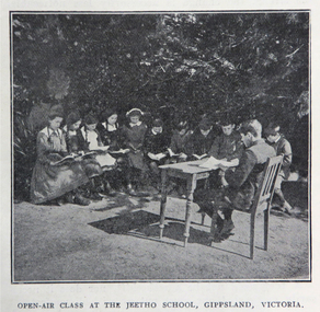
... Relief Fund, William Park obituary, Closer Settlement Act 1912... Relief Fund, William Park obituary, Closer Settlement Act 1912 ...Black hard covered book with red spine, holding Victorian Education Gazettes for one calendar year. .1) 1910 .2) 1912 .3) 1911 .4) 1914 .5) 1918 Images: Open Air Classroom Black Rock; Open Air Classroom, Jeetho, Gippsland; Open Air Nurses bedroom, Mildura; Gym at Canterbury School ; Babies and Nurses at Melbourne Foundling Hospital; Camp at Portland; Alexander Peacock Opens a Melbourne School; Unveiling Major Mitchell Memorial at Mt Arapiles; Agricultural Plot; School Interior; Swimming Drill; Graham Dux Prize Board; Bathing Place; Classroom with blackboard and pictures; Major Mitchell's Map; Melbourne, Derbyshire; Market Place Melbourne; The Blackwood; World War One Send-off at The Athenaeum; Scarsdale Old Boy's logo; Sloyd articles for the Field Hospital; World War One; Gifts for Transport to the Wharf; soldiers; ANZAC Day; ANZAC Day Medalion .5) 1915: Education Department's War Relief Fund, William Park obituary, Closer Settlement Act 1912, Agriculture, needlework, Swimming and Life Saving, explorers, Gregory Blaxland, Matthew Flinders, Composition, Geography, potatoes, onions, gardens, Needlework for Infants, Iona and Staffa, Trained Primary Teacher's Course, Electricity, Electrical Technology, hygiene, Arbour Day, Horticulture, Wattle Day, Bird Day, Technical Schools, Landing at Gaba Tepe, Evils of Alcohol, Old Boys of Scarsdale, Belgium, Teachers' College Images: The British at War, The Sonnet, History and Patriotism, Male Swimming Teachers Summer School at Geelong, Women Swimming Teachers at Port Fairy, Buln Buln State School, Burwood East State School, needlework plans, methods of Rescue and Resucitation. plan of the journey of Gregory Blaxland, Macquarie House, teachers killed (William Ross Hoggart, Stanley Robert Close, William Roy Hodgson, Campbell McDiarmid Peter, William Henry Dawkins, William Hugh Hamilton, Frederick McRae Neal, Vernon Brookes, Frank J. Olle, Alfred J. Collins, Ernest R. Fairlie, William J. McLaren, A.E. Smith, Thomas Patton, Francis W. Kemp, Frederick G. Hall, Rupert O. Hepburn, Woolston J. Govan), Frederick Harold Tubb VC, Botanic Gardens Red Gum, Shelter Pavillions, Head of Wheat, Australian Commonwealth Flag, Iona Cathedral, Drawing exercises, ANZAC Madallion, School Rolls of Honor .6) 1916 - Nature Study, war relief, school gardening, horticulture, singing class, geography of the war, School Rolls of Honour, Ponsonby Carew-Smyth, Astronomy, ANZAC Day, Empire Day, Arbor Day, "Some Suul of Goodness in Things Evil" by Frank Tate, War Relief Gardeners' League, ANZAC Day medallion, Solar System, Abolition of German Schools in Victoria, ANZAC Avenues, avenues of honour, Geography of the War: The West, War relief and handwork, Victorian State Schools Horticultural Society, Patrick Maloney obituary, formalin lamps, Victoria League of Victoria, Wonwondah East Roll of Honor Images - Teachers killed (John Clarke, A.C.H. Jackson, Alexander Robertson, Noel Gambetta, Ralp E. Leyland, Laurance J. Woodruff, Walter E. Cass, Percy D. Moncur, Thomas M. Carmichael, Edward G. Brain, Reginald N.F. Woods, George E. James, William Colvin, David Dobson, Stanley L. Robinson, Charles Allen, G.E. James, H.F. Curnow, Franl L. Cousins, James R. Thompson, Henry H. Campbell, George E. Read, Ernest D. Morshead, Wilfred S. Merlin, Henry R. Wright, George B. Webb, Noel Nicholas, David H. Thomas, Charles A. Levens, Thomas R. Fenner, John M. Daniell, P.J. Larkin, Ralph Smith, Philip Ormsby), school rolls of honour, Swimming Instructors at Queenscliff, The Southern Sky, Map of the North Sea and its Littorals, Easter School of Horticulture at Oakleigh, Map of the Eastern Front, Map of Mesopotamia, Map of the War Area in the Egyptian Campaign, leeches for the Melbourne Hospital .7) 1917 - Swimming and Life-Saving, Childre's FLower Day, Education Department's War Relief Fund, State War Council, Horticulture, Bird Day, Swimming, Growing Chicory at Cowes Images - Teachers killed during World War One (G.M. Nicholas, William C.W. Spencer, J.W.C. Profitt, Ivon C. Bromilow, John Colwell, Robert W. Campbell, Arthur P. Bourchier, Francid G. Houston, Claude N. Harrison, Edgar Williams, Leslie A. Stevens, Charles E. W. Chester, Stanley R. Green, Walter Baker, Arthur G. Scott, Harry L. Swinburne, Horace W. Brown, Arnold Bretherton, Edward W. Jenkins Aubrey Liddelow, Ewen A. Cameron, Edmund R. Lyall, John H. Martin, Harry Bell, Frank L. Nicholls, Melville R. Hughes, Edwin W. Hauser, Walter S. Filmer, Walter G. Barlow, Henry A. Donaldson, Edward H. Jones, Walter W. Raw, Alfred W. Dean, Wiliam Lea, Frederick G. Drury, J.T. Richards, Norman G. Pelton, Lance-Corporal Doran, Kenneth F. McKenzie, William F. Robertson, Wiliam Jarrott, Norman Graham, George G. Paul, Victor Green, Arthur William Rennie, Alfred J. Glendinning, Robert B. Liston, Eward P. Toll, George Jones, Errol E. Rodda, Christian P. Christensen, Charles F. Sydes, H.G. Clements, Norman C. Fricker, J.M. Romeo. Eric N. Lear, Thomas J. Bartley, Norval Birrell, Frederick H. Tubb. J.T. Hamilton Aram, Arthur Wilcock, William M. Conroy, Alex. H. Miller, Patrick J. Cunningham, Charles S. Mitchell, John R. Maddern, James Roadknight, Harry Arundel, Jack C. McKellar, duncan M. McKellar, George S. Manfield, Edgar C. Holmes, George A. Young, Raymond A. Gardiner, William B. Bell, William Opie, George R. Scott, Richard V.B. Vine, Herbery S. Marshall, Hugh St Omer Dentry, George B. Fullerton, Harry Oulton, Iva F. Morieson), School Honor Books, Drawing, Presentation of 30,000 pounds to the British Red Cross at Melbourne Town Hall .8) 1918 .9) 1919 - Photographs of World War One soldiers from the Education Department, Margaret Montgomery Memorial, 1918 Act relating to State School Teachers, State Scolarships, Victorian State Schools' Horticultural Society, Pneumonic Influenza, Spanish Flu, epedemic, swimming and life savinfJunior cadet training, vacancies in Fiji, School Committees, Arbor Day, Arbour Day, Henry Harding of Yinnar, Planting Trees and Shrubs, Juvenile Crime, The use of 'Get', Soldier-Teachers from Overseas in Congress London, Australia's Effort in the War, Military, Working Bees, Tree Planting, fence building, Welcoming Home a Returned Soldier, Avenue of Honour planting, Discipline, Unveiling an Honor Board, School gymnasium, school tennis court, E. E. Crogger grave at Aldershot, The School Honor Book. War Relief Fund, Commonwealth War Record, Caulfield Military Hosptial, ANZAC Day Pilgrimage, Jimmie Panikin, Donald Fraser, Arthur Mee, Card Sun Dial, Balboa Day in Honolulu, William Hamilton, Alfred Jackson, The Backward Child, Flies, Language Teaching and Learning, Spelling, The Education of the Adolescent, victorian education gazette, education gazette and teachers' aid, sloyd, william a. cavanagh, james i froebel, school, education, world war one, memorials, alfred williams, exploration and settlement, cadets, australian naval college, bernard o;dowd, birds, swimming, drawingempire league, eucalypts, paper in history, forestry, arbor day, identification of trees, forestrey museums, fiji, gravel hill school band, horticulture, hygiene, gould league of bird lovers, life saving, la perouse, bandin, j. holland, w. hamilton, charles sturt, principles of archimedes, james holland, william hamilton, scarsdale old boys' reunion, foundling home melbourne, montessori education, open air schools, james hughes, marie corelli, flinders sydney harbour, major mitchell's map, tooth brushing, r.h.s. bailey -
 Federation University Historical Collection
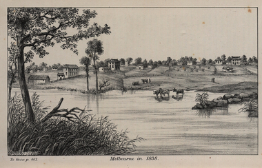
Image, John Helder Wedge, Melbourne in 1838, 1938
... settlement, close to where the Immigration Museum at the Old Customs... settlement, close to where the Immigration Museum at the Old Customs ...The following information is from http://melbourneday.com.au/about.html, accessed 30 August 2016 Melbourne was founded on 30 August 1835 by settlers who sailed from Van Diemen’s Land (Tasmania) aboard the schooner Enterprize. They landed on the north bank of the Yarra River and established the first permanent settlement, close to where the Immigration Museum at the Old Customs House — on the corner of William and Flinders Streets — stands and the place today known as Enterprize Park. Melbourne Day Committee was established to help correct the record about the founding of Melbourne and celebrate its anniversaries. The settlers came from Launceston in search of sheep-grazing land. Land had become expensive and there had long been stories told by whalers and sealers working in Bass Strait of fertile land to the north. This was the southern part of the colony of New South Wales, which the Colonial Government did not want settled at that time. After the Henty family crossed Bass Strait and settled at Portland in 1834 others quickly followed. The north bank was chosen because a small waterfall, or rapids, stopped further progress up the river. The waterfall also separated the tidal movement, providing a vital supply of fresh water. The site had previously been noted by the colony of New South Wales' surveyor, Charles Grimes, in 1803. The north bank also offered more stable, suitable ground. The people of the Kulin nation are the traditional owners of the land that became Melbourne — including the Boonwurrung, Woiwurrung, Taungurung and Djadjawurrung people, who gathered in this place for ceremonies and cultural activities. The topsail schooner Enterprize you see today is a full-size replica of the one that brought the settlers and has become a symbol of Melbourne Day. Her keel was laid at Polly Woodside Maritime Museum in 1991, and the $2.5 million, 27m vessel was launched by Felicity Kennett on 30 August, 1997, at Hobsons Bay. The original ship was bought by John Pascoe Fawkner in April 1835 specifically to search for a suitable place for a settlement in the Port Phillip District. After helping establish Melbourne, the original Enterprize continued operating as a coastal trading vessel for a number of years. She eventually disappeared off the shipping register in 1847, having been wrecked on a sand bar in the Richmond River in northern NSW, with the loss of two lives. The replica is managed by the Enterprize Ship Trust, a not-for-profit organisation. The first settlers were those on board the Enterprize — her crew and passengers. They were John Lancey , master mariner and Fawkner’s representative; Enterprize's captain, Peter Hunter; George Evans, plasterer/builder; carpenters William Jackson and Robert Hay Marr; Evan Evans, George Evans’ servant; and Fawkner’s servants ploughman Charles Wise, general servant Thomas Morgan, blacksmith James Gilbert and his pregnant wife, Mary. And Mary's cat! Enterprize set sail on her historic voyage from Launceston on July 21, 1835, stopping at George Town in northern Tasmania where creditors detained Fawkner. He was therefore not part of the first trip to Melbourne. Enterprize then left on August 1 under the command of captain Hunter. The expedition was led by Lancey, Fawkner's delegate. The party first considered Western Port and the eastern side of Port Phillip for a place to settle, before deciding on the Yarra’s north bank — known today as Enterprize Park. On Sunday, August 30, they disembarked and began to erect shelter, build a store and clear land to grow food, thus starting the permanent European settlement of Melbourne.Image of the fledgling town of Melbourne on the banks of the Yarra River. melbourne, yarra river, john helder wedge -
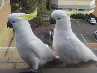 Federation University Historical Collection
Photograph - Photo, Clare Gervasoni, Cockatoos visit the Geoffrey Blainey Research Centre at Federation University Australia, 2014, 12/06/2014
The sulphur crested cockatoo (scientific name Cacatua galerita) is a large white parrot with dark grey-black bill, a distinctive sulphur-yellow crest and a yellow wash on the underside of the wings. Sexes are similar, although the female can be separated at close range by its red-brown eye (darker brown in the male). Sulphur-crested Cockatoos are found in a variety of timbered habitats and are common around human settlements. The birds stay in the same area all year round. (http://www.birdsinbackyards.net/species/Cacatua-galerita, accessed 12/06/2014)Two Sulphur-crested cockatoos on the window ledge of the Geoffrey Blainey Research Centre at Federation University Australia. Numerous birds visit 'dance' along the window ledge including cockatiels, Magpie Larks, Crows and Rosellas.federation university australia, geoffrey blainey research centre, cockatoo, birds, native birds, sulphur-crested cockatoo -
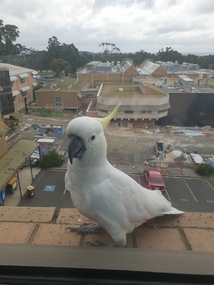 Federation University Historical Collection
Photograph - Photo, Clare Gervasoni, Cockatoos visit the Geoffrey Blainey Research Centre at Federation University Australia, 2019, 21//2019
The sulphur crested cockatoo (scientific name Cacatua galerita) is a large white parrot with dark grey-black bill, a distinctive sulphur-yellow crest and a yellow wash on the underside of the wings. Sexes are similar, although the female can be separated at close range by its red-brown eye (darker brown in the male). Sulphur-crested Cockatoos are found in a variety of timbered habitats and are common around human settlements. The birds stay in the same area all year round. (http://www.birdsinbackyards.net/species/Cacatua-galerita, accessed 12/06/2014)Two Sulphur-crested cockatoos on the window ledge of the Geoffrey Blainey Research Centre at Federation University Australia. Numerous birds visit 'dance' along the window ledge including cockatiels, Magpie Larks, Crows and Rosellas.federation university australia, geoffrey blainey research centre, cockatoo, birds, native birds, sulphur-crested cockatoo